With the application and research of wind measurement lidar in multiple scenarios in the wind power industry for many years, it is no longer an unfamiliar product for the wind power industry. Wind power related engineers will choose wind measurement lidar as an important tool for wind measurement when they are working. Thanks to the unremitting efforts of wind measurement lidar manufacturers, wind turbine OEMs and wind power owners, the price of wind measurement lidar has been greatly reduced compared with a few years ago, which has also led to a significant increase in the market capacity of wind measurement lidar. According to incomplete statistics, in 2020, the domestic wind power industry has delivered more than 150 ground-based wind-measuring lidars and nearly 1,000 nacelle-mounted wind-measuring lidars. Five years ago, the corresponding figures were less than 10 units and less than 5 units. The growth of market capacity has also optimized the industrial chain of wind-measurement lidar and the product development capabilities of lidar manufacturers. These changes will continue to feed the market, and the price of wind measurement lidar will be further lowered in the future, which is bound to form a trend for wind Lidar contributing significantly to “Zero Carbon” target.

Wind LiDARs' Application in Different Wind Project Stages
| Project Prospecting | Design and Assessment | Operation | Old Wind Farm Retrofit / Resale | |
| Wind Resource Assessment | Investability Assessment |
|
| |
| Wind Turbine Performance Assessment |
|
| ||
| Load Control & Optimization |
|
|
|
At present, there are two main technical routes for wind measurement lidar in the market, namely pulsed coherent detection and continuous coherent detection. The application forms include ground-based wind measurement lidar, nacelle mounted wind measurement lidar and 3D scanning lidar. This paper mainly discusses pulsed coherent detection application in the wind power industry. The measurement principle of pulsed coherent detection wind Lidar is as follows: the laser generates signal light and transmits it into the air to be measured through the optical antenna and scanning mechanism, and interacts with the aerosol particles in it to generate a backscattered signal containing its velocity information. It can be known from the Doppler principle that the Doppler frequency shift fd of the echo signal is proportional to the moving speed of the aerosol particles (that is, the wind speed), so the backscattered signal received by the optical antenna passes through the local oscillator generated by the fiber laser in the system. The optical beat frequency and digital demodulation can be processed to obtain the radial wind speed. The scanning mechanism controls the laser emission direction, emission frequency and the number of periodic beams, and then builds a time-space model, under which the radial wind speed in the period is synthesized into the target wind speed. For example, the Molas B300 ground-based wind lidar adopts the VAD scanning method to obtain the space vector wind speed through 4 beams, and then obtain the horizontal wind speed, wind direction and vertical wind speed.
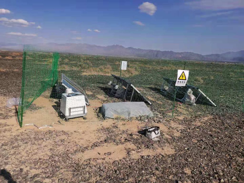
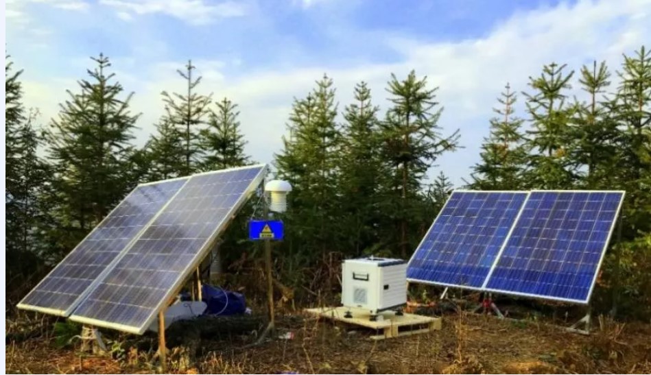
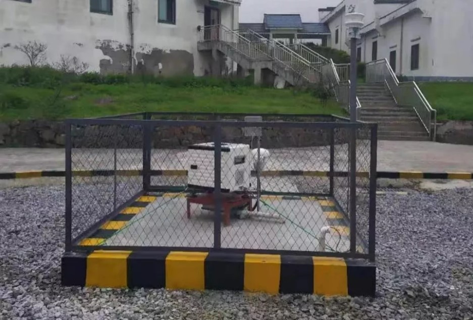
Ground-based wind measurement lidar is the earliest application form in the wind power industry. Its emergence has replaced part of the market for wind measurement towers and made up for the work that some wind measurement towers cannot complete.
Compared with wind towers, wind Lidar has the following advantages:
#1 Long Range
Can measure up to 300m, which can cover the whole wind turbine rotor
#2 Flexible Deployment
Easy to install, and can be used repetitively
#3 Quick Setup
Can be setup in same day, and start to get the wind data at the same time.
#4 Development Friendly
Lower land use, and can be easily accepted by local government, authorities and residents
#5 Low Safety Risk
Much less construction work, no working at height risk
#6 Environment Adaptive
Can work betwe -40℃ and 50℃, and under snow or frozen weather
With the establishment of the international standard for ground-based wind measurement lidar (IEC61400-12-1), the certification and testing of third-party authoritative organizations, and a large number of applications and research in the wind power industry, its measurement accuracy has been widely recognized in the industry, and more and more OEMs, third-party organizations and owners use it in all stages of wind farm construction. The main applications include: wind resource assessment, power curve testing, wind power prediction, load testing, etc.

1) Wind resource assessment
In the macro site selection stage of the wind farm, the use of wind measurement lidar for short-term wind measurement can quickly decide whether to continue the project investment, saving time and cost and reducing project risk with the most economical means.
In the micro-siting stage, the use of wind measurement lidar short-term wind measurement combined with wind tower data can more accurately simulate the wind resources of the entire wind farm, especially the wind resources of the wind turbine site, which can effectively avoid the investment risk of a single unit, accurately calculate the power generation income and ensure the safety characteristics of the unit.

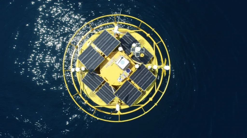
With the rapid development of offshore wind power, offshore wind resource assessment has become an urgent need in the industry, while the traditional offshore wind tower has the disadvantages of expensive cost, complicated approval procedures, long construction period, etc. Wind measurement LiDAR has become the first choice for offshore wind measurement. Different from onshore wind measurement, lidar in the sea wind measurement needs to have a corresponding physical carrier, the current carriers are fixed platform and buoy two forms, of which the platform refers to the existing fixed carrier such as oil drilling platform, lighthouse, boost station, etc., offshore platform wind measurement investment is small but platform resources can not be sought, buoy as a carrier (Flidar) has become the mainstream form of current offshore wind measurement. IEAWind TCP TASK32 is developing Flidar related standards, and the introduction of related standards will help the specification use of Flidar and the development of related technologies. As a relatively important resource of the country, the safety and reliability of its data is particularly important, and the localization of wind measurement lidar carried by Flidar will become a major trend of development.
2) power curve test
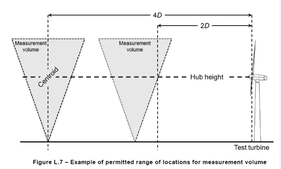
According to the provisions of IEC61400-12, the wind turbine power curve verification standard issued by the International Electrotechnical Commission, the measurement of the wind turbine power curve must be made by the wind tower, and the distance between its position and the generator set should be 2 to 4 times the diameter of the wind turbine, and the wind measuring tower must be located in the selected measurement sector. However, after the completion of the wind farm construction, the original built wind tower location is difficult to meet the requirements of the power curve test, and there will be many restrictions on the new wind tower, including terrain, land acquisition, construction cycle, price, etc., which makes the implementation of the power curve test more difficult. In the 2017 revision of the IEC61400-12 standard, the wind measurement lidar is included in the list of equipment that can be used for power curve testing, due to the flexible deployment of wind measurement lidar and other characteristics of the power curve test into an easy implementation of the project, has been DNVGL, Windguard and other technical authorities for practical test applications.
3) wind power forecast
In order to ensure the safe and stable operation of the power system, implement the national renewable energy policy, and standardize the management of wind power grid-connected dispatch and operation, all wind farms connected to the grid should have the ability to forecast wind power, and carry out wind power forecasting and forecasting as required. The traditional wind measurement method of wind power prediction is to build a wind measuring tower within 5 km of the wind farm, unaffected by the wind farm wake and in the wind farm dominant wind. Due to the issue that the wind tower freezes in winter, it is prone to collapse accidents, there are serious safety hazards, and it is easy to cause grid assessment after data interruption. The construction of wind towers also has complex land acquisition procedures, long construction period, high cost, and difficult maintenance. With large wind measurement height, small footprint, short construction period, high reliability, and no risk of collapse, lidar has gradually shown its advantages in power prediction systems. Based on the characteristics of small and safe lidar, if conditions permit, the owner can choose to deploy the lidar in the booster station, whether it is construction procedures or maintenance, compared with the wind tower has obvious advantages, especially the sea rise station, the use of lidar instead of the wind tower economic benefits are more prominent.
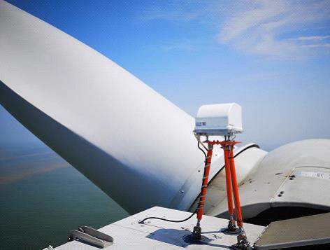
Different from the high degree of overlap between the functions of the ground-based wind measurement lidar and the wind tower, the nacelle wind measurement lidar is a new application in the wind power industry, which can measure the wind speed in front of the wind turbine blade without being affected by the blade turbulence, and the main applications include: feed-forward control, yaw correction and power curve testing.
1) feedforward control
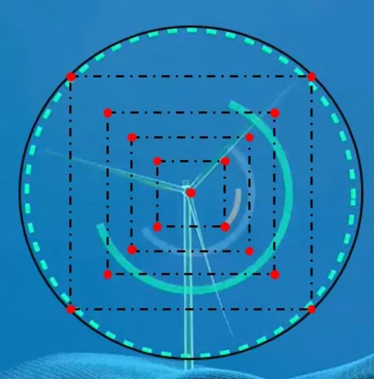
Feed-forward control is the main application of nacelle lidar. At present, more than 1500 units around the world have connected the nacelle wind lidar to the control system of the wind turbine. And more than 90% of nacelle wind lidars are with no less than 4 beams because of the fact that more beams can obtain richer incoming flow information in front of the blade, and then simulate the wind speed of the entire rotor surface.
Feed-forward control based on nacelle wind lidar enables:
(1) the intelligent yaws to increase the power generation of the unit by more than 2%.
(2) reduce fatigue load, reduce rotor speed fluctuations and power fluctuations
(3) realize the ultimate wind condition control and reduce the limit load
(4) realize complex wind condition control and reduce the operation risk of the wind turbine
(5) adaptive control of wind conditions, flexible deployment of control strategies according to wind conditions
(6) multi-turbine network control of wind farms reduces the impact of wakeage on the entire wind farm and increases the power generation of the entire wind farm.
Affected by many factors, the popularity of nacelle wind lidar in the wind turbine is far from reaching expectations, in recent years, almost all wind turbine OEM have expressed strong interest in feed-forward control technology based on nacelle wind lidar and began corresponding tests and studies, with the deepening of research and control of nacelle wind lidar costs, the nacelle wind lidar market will be greatly improved and even become the standard components of wind turbines.
2) yaw correction
The use of nacelle wind lidar can achieve two yaw modes, the first mode is the aforementioned nacelle wind lidar into the wind turbine main control system, to achieve real-time yaw control; the second is to install the nacelle wind lidar in the wind turbine for a period of time (mostly about a month) to collect the deviation information between the turbine orientation and the wind direction, dismantle the nacelle wind lidar after the measurement, calculate the deviation of the unit orientation through the nacelle wind lidar data, and correct the deviation value into the wind turbine control system, so as to achieve the purpose of yaw correction. Mode 1 needs to cooperate with the wind turbine control strategy to achieve yaw goals, while the nacelle radar in mode 2 does not need to be connected to the main control system, which is easier to implement, so mode 2 has become the first choice for many customers.
3) power curve test
IEC61400-12 standard proposes to use the impeller diameter of 2 to 4 times the wind speed for power curve calculation, and the common nacelle wind lidar range for feed-forward control is less than 200m, and in order to be able to measure the entire rotor surface wind speed, its upper and lower beam tension angle is too large, even if the rotor diameter of 2-4 times the wind speed can be measured, its synthetic wind speed and the real wind speed will have a large deviation. Therefore, a nacelle wind lidar suitable for power curve testing was required. The Molas NL400 introduced by Movelaser has been improved on the original nacelle wind lidar, and its measuring range has been upgraded to 400m, which can easily measure the wind speed at the diameter of the unit 2 to 4 times the rotor diameter. The upper and lower tension angles were changed to 10° to ensure the accuracy of wind speed at long distances. The current standard IEC61400-50-3 on nacelle wind lidar for power curve testing is being prepared and is expected to be promulgated in 2022. A power curve test method based on nacelle wind lidar, written under the auspices of DTU, has been made public.
Since the cabin radar is installed in the unit and has been accompanied by the rotation of the turbine, compared with the use of wind tower or ground-based radar for power curve test, the data available sector is not affected by the wind direction, and the wind speed data of each wind speed section can be collected in a shorter time. For areas where towers or ground-based radars cannot be erected or installed in mountainous areas and seas, the advantages of using nacelle lidar for power curve testing are more obvious.